Mapmaking

Elements area

Taxonomy

Code

Scope note(s)

    Source note(s)

      Display note(s)

        Hierarchical terms

        Mapmaking

          Equivalent terms

          Mapmaking

          • UF Orienteering
          • UF Maps
          • UF Navigation
          • UF Wayfinding

          Associated terms

          Mapmaking

            8 Archival Records results for Mapmaking

            8 results directly related Exclude narrower terms
            F223-S3-f1-CO3N · 1911
            Part of No Place Too Far

            When European settlers first explored the North Shore Mountains, they had no maps. Creating their own surveys and making their own maps formed part of their expeditions.

            This beautiful hand-drawn map of the backcountry area north of Indian Arm and Coquitlam Lake was made by Neal Carter and is one of the first paper maps of the area — or perhaps even the very first. The map is part of a photo album he made showing peaks of the area. Attached to the map is a 2 page account by Nellie Fraser of expeditions of Coquitlam Mtn. by ACC members.

            Neal Carter
            [Map of Green River]
            F223-S3-f1-C-A3
            Part of No Place Too Far

            The first European settlers to explore the Garibaldi area had no maps. Doing their own surveys and making their own maps formed part of their expeditions.

            This beautiful hand-drawn map of the Green River area near Whistler, made by Neal Carter, would have been one of the first to be made. The map is part of a photo album he made showing peaks of the area.

            Neal Carter
            [Map of Mt. Garibaldi]
            F223-S3-f1-C-A2 · 1911
            Part of No Place Too Far

            The first European settlers who explored the Garibaldi area had no maps. Doing their own surveys and making their own maps formed part of their expeditions.

            Neal Carter took on the challenge and hand-drew some beautiful maps from his own surveys. This beautiful map of the Garibaldi area was one of the first to be made, if not the first. The map is part of a photo album he made showing peaks of the area.

            Neal Carter
            [Map of Pitt Lake Area]
            F223-S3-f1-RR1
            Part of No Place Too Far

            The first European settlers who explored the mountains around Vancouver and beyond had no maps. Doing their own surveys and making their own maps formed part of their expeditions.

            This beautiful hand-drawn map of the area round Pitt Lake, Alouette Lake and Stave Lake made by Neal Carter would have been one of the first to be made, if not the first. The map is part of a photo album he made showing peaks of the area.

            Neal Carter
            No Place Too Far
            NPTF

            Imagine looking up at a rocky peak. You know of no ascent and the eyes of your fellow climbers are on you to be the first. If you choose the wrong route, or if you slip and fall, it could be the last thing you do as help is days away. With no safety protection at all, you take a deep breath and set off.

            The settler immigrants who became the early North Shore mountaineers were a courageous bunch. They had no maps or trails and only very basic equipment. Yet their passion for adventure was so great that they overcame any concerns they may have had. They planned expeditions to areas in the Pacific Northwest that are remote even today. No mountain was too far for them to explore and no peak too high for them to attempt.

            Despite the lack of technology and equipment and the lack of information on areas, they planned trips meticulously. Being part of clubs like the BC Mountaineering Club helped bring together expertise and resources.

            Over the decades, their activities paved the way for advances in the very things they had little of in the earliest years, such as maps, shelters, established trails, and a search and rescue team.

            Today, the North Shore has one of the best search and rescue teams in the world. Founded in the 1960s by volunteers who were the very mountaineers and skiers that had such expertise and passion for the mountains, it is perhaps not surprising that the team has evolved into the leaders they are now.

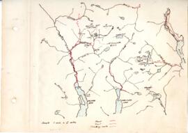
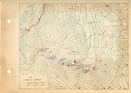
            This selection of archives gives a glimpse into some of these incredible expeditions — some of them incredible for achieving so much with so little. One example is the first recorded ascent of Mount Garibaldi in 1907. Photos taken on the expedition show just how basic their clothing and equipment was. Other archives show the beautiful hand drawn maps of the local mountain ranges created by Neal Carter, all created with just basic surveying equipment.

            "The Cheam Range"
            F223-S3-f1-CH1
            Part of No Place Too Far

            The first European settlers who explored the mountains around Vancouver had no maps. Doing their own surveys and making their own maps formed part of their expeditions.

            This hand-drawn map of the Mount Cheam area in the Fraser Valley, made by Neal Carter would have been one of the first to be made. The map is part of a photo album he made showing peaks of the area.

            Neal Carter
            F223-S3-f1-C-A13
            Part of No Place Too Far

            Item F223-S3-f1-C-A130 shows a photo of Mount Garibaldi from Mount Mamquam. In this tracing, Neal Carter has shown in red the route taken across the landscape.

            The tracing is part of a photo album he made showing peaks of the area.

            Neal Carter